Iran nuclear and military damage revealed after restricted satellite images released

 BBC
BBCThe extent of damage to some of Iran's military and nuclear sites has been revealed for the first time after more than a quarter of a million previously restricted high-resolution satellite images were released.
A leading satellite imagery provider, Planet Labs, restored access to images from nearly 800 locations in Iran which they had chosen to restrict following a request from the US government.
BBC Verify analysed satellite imagery from two key locations - Esfahan and Bushehr - captured since restrictions began on 9 March.
The images show a variety of targets hit from ammunition storage areas to ballistic missile infrastructure, nuclear and surface-to-air missile sites, and naval bases, according to military intelligence company Janes.
Verified videos have previously shown these locations were subject to US-Israeli strikes but these newly available images provide an insight into the specific targets of the attacks and the extent of the damage.
Bushehr
Several sites around the coastal city of Bushehr have been damaged or completely destroyed since 9 March, images show.
Military buildings and government facilities including aircraft hangars, ammunition storage, dockyards, piers, and missile launch sites have been visibly damaged, according to Janes, with the affected sites belonging to both the Iranian government and the Islamic Revolutionary Guard Corps (IRGC).
Many buildings have caved-in roofs and some appear completely flattened. Other images show destroyed aircraft and sunken ships. Craters can also be seen on multiple runways, including at Bushehr International Airport - some of which have since been repaired.
In some areas - designated as "military" on online maps like OpenStreetMaps - nearly every single building has been destroyed.
The damage seen "correlates with the US and Israeli reports of a wide-ranging strike campaign, not only designed to engage standing forces, but degrade the infrastructure behind them", Janes Middle East defence specialist Jeremy Binnie said.
Construction and repair sheds at a naval dockyard have also been damaged, according to Janes analysis.
Esfahan
Images of the province of Esfahan, which is home to two nuclear facilities - in the city of Esfahan and Natanz - reveal the extent of damage to military infrastructure.
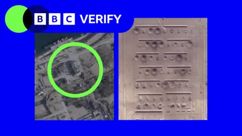
At military bases in the region, damage to buildings are clearly visible. Buildings - identified by Janes as an ammunition storage area for an airbase - have been damaged at the strategically important Shekari 8 Iranian airbase.
More than 60 structures have been severely damaged or destroyed at a military base in the south of the city.
Another dozen were hit at another base further south in the region, near the town of Baharestan.
The controversial decision to restrict access to images has limited how journalists, humanitarian groups and analysts assess the impact of the US-Israel war with Iran, including damage to military targets and civilian infrastructure.
Restrictions still remain in place for Planet's imagery across most of the Middle East including Iraq, Lebanon, Israel and Gaza.
The California-based company said that a "delay remains in place over other parts of the region and we will continue with managed distribution for those areas in accordance with ongoing national security and personnel safety concerns".
In the absence of Planet's services, its news clients - such as the BBC and the New York Times - have been turning to non-US based solutions.