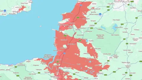
Map shows risk to coastal towns as sea levels rise

 North Somerset Council
Parts of seaside towns are at risk of disappearing under rising sea levels, according to research.
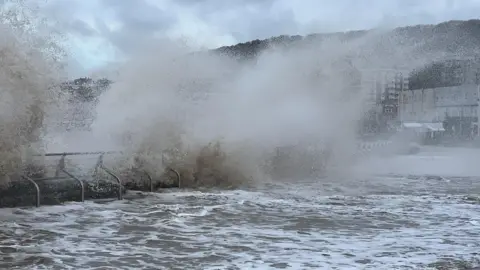
Coastal areas along the Bristol Channel, which has one of the largest tidal ranges in the world, are vulnerable to flooding risks and by 2050, and researchers at Climate Central say sections of villages and towns could be submerged underwater.
The group, made up of independent scientists, have created an interactive map based on current data and global mapping tools.
A North Somerset Council spokesperson said rising sea levels are a genuine long-term challenge, but there has been significant investment in sea walls and flood management systems to protect communities.
 Climate Central
Why are parts of Somerset at risk of disappearing?
Sea level rise is already happening and is being measured around the UK coastline.
For North Somerset, this matters because the Bristol Channel has one of the largest tidal ranges in the world.
Several coastal and low-lying communities are already dependent on flood risk management including sea walls.
But rising sea levels increase pressure on those systems over time. A defence that provides a high level of protection today may provide a lower standard of protection in future unless it is maintained, improved or adapted, a council spokesperson added.
The UK has a well-established national tide gauge network, including gauges in the Bristol Channel area.
These gauges continuously record sea levels and the data is used for flood warning, storm surge forecasting, coastal science and understanding long-term sea level rise. This monitoring shows that UK sea levels have risen over the last century, and that the rate of rise has increased in recent decades.
Daniel Gilford, climate scientist at Climate Central, said: "The effects of human-caused climate change are already here.
"We will continue to face growing threats like increasing coastal flood risks unless we immediately and sharply reduce our climate pollution."
What is the council doing to protect the area?
 Getty Images
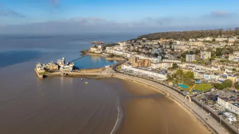
North Somerset Council said it is developing a long-term coastal transition and investment plan to identify where and when future upgrades are likely to be needed.
The aim is to make sure future funding is targeted to the right locations at the right time, based on the latest modelling, Environment Agency evidence, sea level projections, asset condition information and the needs of our coastal communities.
Council chiefs said flood maps like Climate Central's help people visualise how rising sea levels could affect low-lying coastal areas, but often do not account for existing flood defences.
The council spokesperson added: "Working closely with the Environment Agency, we are maintaining and improving these defences now, while planning ahead to ensure the right upgrades are in place for the future.
"Our focus is on managing risk over time, supporting community resilience, and making sure North Somerset remains a safe and viable place to live and work."
Follow BBC Somerset on Facebook and X. Send your story ideas to us on email or via WhatsApp on 0800 313 4630.