Summary

  1. Ice, snow, rain and wind... what can I expect in the coming days?published at 14:09 GMT 7 January

    The Met Office has issued a number of amber and yellow weather alerts for the days ahead. Here's a breakdown of how you may be affected:

    Ice:

    • Icy conditions are expected to cover Northern Ireland overnight, with a yellow warning in place from midnight until 10:00 GMT tomorrow.
    • Yellow snow and ice warnings in place for Scotland and northern England from 22:00 today until 12:00 tomorrow.
    • The same warning will be in place for northern Scotland from midnight tonight until midnight tomorrow.

    Snow:

    • Yellow snow warnings are in place for parts of south-west England from 20:00 tomorrow to 09:00 on Friday, and for most of the rest of England and Wales from 17:00 tomorrow to 12:00 on Friday.
    • The amber warnings for snow are in place for "dangerous conditions" in the Midlands, south-west England, Wales and Yorkshire from 20:00 tomorrow to 09:00 on Friday.

    Rain:

    • Flooding is possible as yellow alerts for rain in south-west Wales come into effect from midday tomorrow into 10:00 on Friday and for east Midlands, east England and Yorkshire from 18:00 tomorrow until 21:00 on Friday.

    Wind:

    • London, south-east England, south-west England and Wales can expect strong winds from 15:00 tomorrow until early the next morning with a yellow warning.
    • An amber alert exists for south-west England where "exceptionally strong" winds are expected between 17:00 and 23:00 tomorrow.

  2. Financial support extended as freezing temperatures persistpublished at 13:42 GMT 7 January

    Kevin Peachey
    Cost of living correspondent

    The number of areas where vulnerable people can receive financial help for heating costs during freezing weather has been extended in the last 24 hours.

    Cold weather payments have now been triggered across 697 postcode areas in England, Wales and Northern Ireland. In total, more than one million households will receive money.

    A payment of £25 is paid to a household on certain benefits for each seven consecutive day period when the average temperature in a local area is recorded as, or forecast to be, 0C or below. So, people in some postcode areas will receive more than one £25 payment.

    The money is paid automatically into a bank account within 14 days to those eligible - marked as DWP CWP.

    You can read more here What are cold weather payments and who can get them? - BBC News and also find links to check whether you are eligible.

    A separate winter heating payment system operates in Scotland.

    An elderly woman touches a radiator and holds a piece of papersImage source, Getty Images
  3. NHS England says weather increasing pressure on health servicepublished at 13:35 GMT 7 January

    "Many places" across the NHS are seeing more patients as a direct result of cold weather, says NHS England.

    “We are seeing the impact on people with respiratory problems, and we’re also seeing more injuries from slips and falls due to the icy conditions," it says in a statement.

    There are also "many patients in hospital beds with flu", adding to the pressures at an "incredibly busy time for the NHS".

  4. Rain, wind and heavy snow - Goretti forecast for next few dayspublished at 13:17 GMT 7 January

    Simon King
    BBC Weather presenter and meteorologist

    Strong winds, heavy snow and heavy rain means that Goretti will be a multi-hazard storm system affecting much of England and Wales, with many amber and yellow warnings in force for Thursday into Friday.

    It will be rapidly developing as it approaches south-west England by Thursday lunchtime - bringing some rain and strengthening winds. Later in the afternoon, wind gusts will increase up to 90mph in the Isle of Scilly and Cornwall which will bring damage and disruption.

    As rain then spreads northward across England and Wales, it bumps into the colder Arctic air we’ve had in place over the past week and will result in the rain turning to snow by Thursday evening.

    Initially this will be on hills and then to lower levels overnight. Accumulations of 10-15cm are likely fairly widely across mid and east Wales, the Midlands and up to the southern Pennines, with the potential for 20-30cm, more especially on the hills of Wales and Peak District.

    Heavy rain could also bring some localised flooding to parts of south-west Wales and Eastern England.

    Snow and rain will then ease into Friday morning but with snow on the ground, there’s likely to be travel disruption for the morning commute.

  5. How has the cold snap affected you?published at 13:01 GMT 7 January

    As snow and icy conditions continue across parts of the UK and Europe, we want to hear about your experiences. You can get in touch in the following ways:

    Please read ourterms & conditions andprivacy policy  

    In some cases a selection of your comments and questions will be published, displaying your name and location as you provide it unless you state otherwise. Your contact details will never be published.  

    Red banner reading 'YOUR VOICE' on righthand side
  6. 'We'd have run out of food days ago if not for local farmers'published at 12:49 GMT 7 January

    Jack Grey
    Live reporter

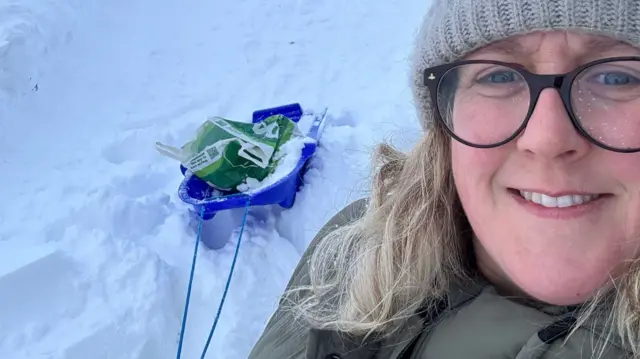
    Alyson with a sledge bringing food back to her house that has been dropped off by a local farmerImage source, Alyson Young

    Without local farmers delivering food to her house, Alyson Young says she and her husband would have been without food "for days" after heavy snow and ice made travel impossible.

    She says the snow in Arbuthnott, rural Aberdeenshire, is the worst she has ever seen in the eight years she’s lived there.

    “Without the farmers we would be completely and utterly stuck,” she tells me - adding that farmers have been checking in with “everybody locally” to make sure they have enough food.

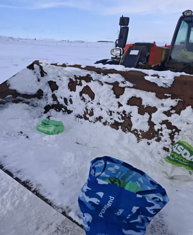
    For those that don’t, she says the farmers have headed out in their heavy duty farm vehicles and delivered food and supplies to those in need.

    On top of that, she says at “all times of day” for the past “four or five days straight” they have been out rescuing stranded motorists, clearing roads and offering to transport people: “They have absolutely been the people keeping us safe and supplied, they’ve been absolutely brilliant.”

    • A major incident was declared by Aberdeenshire Council on Tuesday due to the snow, with schools in the area remaining closed on Wednesday
    Food and supplies in the bucket of a farm vehicle being delivered to those in needImage source, Alyson Young
  7. Yellow rain alert issued in parts of east Englandpublished at 12:43 GMT 7 January

    Among a flurry of weather warnings, the Met Office has now issued a yellow alert for rain - beginning on Thursday at 18:00 in parts of east England.

    The alert warns of "heavy and persistent rain through Thursday night". It will remain in place until 21:00 the next day.

    Areas covered by the alert include Norwich, Ely, Peterborough and Lincoln.

  8. Nine children in Reading injured after collision between school coach and buspublished at 12:29 GMT 7 January

    Nine children have been injured following a collision between a school coach and a bus in Reading.

    One adult and a child have been taken to hospital - it's not thought their injuries are life-threatening.

    "The incident log we have states that our lead clinician reported road conditions were very icy at the scene," a statement from South Central Ambulance Service says.

    The statement adds that "nine children from the school coach have suffered minor injuries, along with the coach driver, and eight adults from the Reading bus suffered minor injuries".

  9. New amber snow alert issued in Midlands and surrounding areaspublished at 12:13 GMT 7 January

    Another amber warning's just been issued by the Met Office - and it's for snow in parts of England.

    This alert is in place from 20:00 on Thursday, until 09:00 on Friday.

    Leicester, Birmingham, Coventry, Derby, Wolverhampton and Hereford are all covered by this one, along with surrounding areas. Parts of Wales, Nottingham and Sheffield are also covered.

    Added to other warnings, this means there are currently six in force for Thursday.

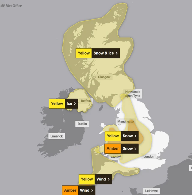
    Here's what the Met's weather warnings UK map currently looks like:

    Map showing parts of UK covered by Met Office weather warningsImage source, Met Office
  10. Amber wind alert issued for Isles of Scilly and parts of Cornwallpublished at 11:59 GMT 7 January
    Breaking

    The Met Office has just issued an amber alert for wind in parts of Cornwall's coast and the Isles of Scilly, coming into affect on Thursday.

    Between 17:00 and 23:00, an amber alert will be in place across the Isles of Scilly, along with Truro, Newquay, Cambourne, Falmouth, Hayle, Helston and Penzance.

    A yellow wind warning - in place from 15:00 on Thursday to 06:00 on Friday - covers the wider south-western region.

    Storm Goretti will bring a spell of strong winds later on Thursday and into Thursday night, which may lead to some disruption, the Met Office says.

  11. After days of deep snow in Aberdeen, my walk to work offered a glimmer of hopepublished at 11:33 GMT 7 January

    Ken Banks
    BBC Scotland North East and Northern Isles reporter

    The heavy thumps of snow falling from the roof during the night may have woken me up, but this morning was a welcome sign that a slight thaw may finally be under way in Aberdeen.

    People were still using shovels to clear pavements but on my trudge to work, it seemed more slush than thick snow.

    Roads were also far clearer than they have been, and cars seemed to have far less snow on them than in recent days.

    The city and the rest of the north-east of Scotland have now been in the grip of deep snow for seven days.

    A number of schools across Aberdeen, Aberdeenshire and Moray are again closed, and it's not yet clear how many may be able to reopen on Thursday.

    Back in November and December 2010, the area endured many consecutive days of deep snow, which again closed schools and caused major travel problems.

  12. Watch out for black ice making driving conditions treacherouspublished at 11:22 GMT 7 January

    Sarah Keith-Lucas and Helen Willetts
    BBC Weather

    Watch out for some particularly slippery conditions this morning especially over higher ground in southern England and Wales.

    Overnight, rain washed away grit in many places and where temperatures then fell below freezing again, the wet surfaces have formed instant ice rink conditions.

    There are already reports of black ice making driving conditions treacherous.

    The warning across central and northern Scotland is valid throughout Wednesday, here the concern is for more snow to fall and spread south across eastern areas.

    This snow will blow around in the brisk wind, reducing visibility for drivers. Then, at lower levels, it’s likely to be rain or sleet falling onto frozen surfaces, leading to black ice.

  13. RAC: Black ice 'very dangerous' and almost impossible to spotpublished at 11:20 GMT 7 January

    Following reports of icy roads across the UK, the RAC is warning that it's "vital" motorists take extra care when travelling due to the risk posed by patches of "almost impossible to spot" black ice.

    It says melting snow and freezing surface water increases the likelihood of encountering black ice, and urges drivers to "slow down" and leave extra space to the car in front.

    The RAC - which offers drivers roadside assistance - says if a car does starts skidding, to "steer gently into the direction of the skid to keep the car straight", using the gears to slow down if necessary.

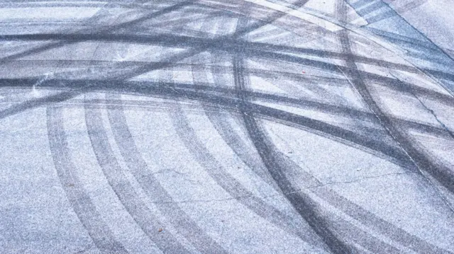
    Skid marks on icy roadImage source, Getty Images
  14. Ice warnings remain for Northern Ireland and Scotland, but expire in England and Walespublished at 10:30 GMT 7 January

    Yellow weather warnings for ice are no longer in place across much of England, Wales and southern Scotland after they expired at 10:00 GMT.

    Northern Ireland remains under a yellow weather warning for ice until 11:00, while a yellow warning for north and north-east of Scotland is due to last until 23:59.

    The Met Office has also issued yellow weather warnings for wind in south-west England for between 15:00 and 23:59 tomorrow, as well as for snow in central England and Wales from 18:00 tomorrow.

  15. Temperatures have dropped 10C below the January average this weekpublished at 10:23 GMT 7 January

    Simon King
    Presenter and meteorologist, BBC Weather

    Getting colder bouts of weather is absolutely normal during January and over the course of winter, especially when our wind comes in from the north or north-east, dragging colder air in from the Arctic.

    But an Arctic blast has meant temperatures falling to around 4-10C below the average for early January over the past week.

    On Tuesday morning the temperature dropped to -12.5C in Norfolk, the lowest temperature there since 2013. And days of heavy snowfall have caused significant disruption across northern Scotland. This has been a notable spell of Arctic weather.

    Cold snaps like this will become less common in our warming climate but they won’t disappear completely. Even with wetter and warmer UK winter overall, getting an Arctic blast for a week or two within those three months will still be possible.

  16. Police in England and Wales warn of uptick in crashes on icy roadspublished at 10:21 GMT 7 January

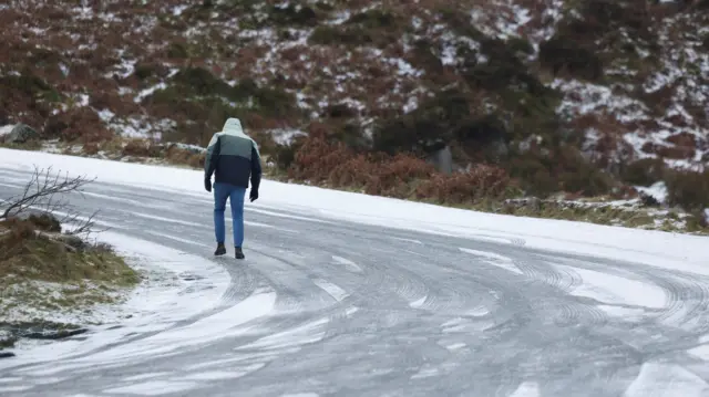
    Man walking on icy roadImage source, Reuters

    Police forces are urging motorists to be cautious on roads after an uptick in crashes in the icy conditions around the UK.

    Here's what some in England are saying:

    • West Midlands Police says it has had a "number of reports of collisions" just this morning as a result of icy roads
    • Leicesteshire Police warn that many roads in the area are "very dangerous", adding that it has had several reports of crashes so far this morning

    And in Wales:

    • Dyfed-Powys Police urged driving overnight to "slow down" and only travel if absolutely necessary.

    The Met Office has been warning of potential injuries due to slips and falls in these conditions.

  17. Schiphol cancels hundreds of flights as European - and UK - airports face disruptionpublished at 09:52 GMT 7 January

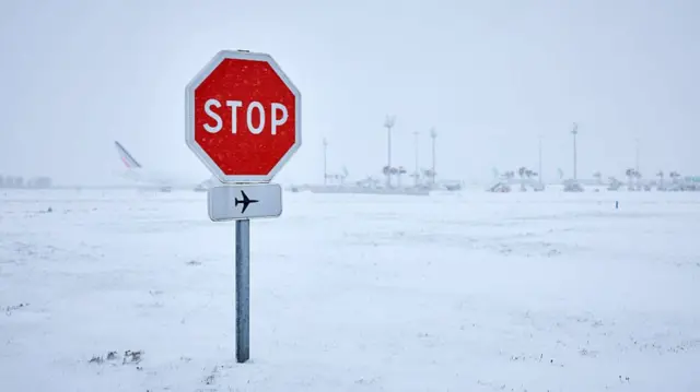
    Stop sign at an airport covered in nowImage source, Getty Images

    The heavy snow and ice has been causing travel disruption across the UK and in Europe since the start of this week. Here's a look at the airports affected today:

    • Amsterdam - Schiphol Airport has cancelled more than 700 flights - mostly European - with more due to be cancelled. More than 1,000 people spent the night yesterday, the airport says
    • Paris - Charles de Gaulle Airport was forced to cancel 100 of its flights while the French capital's Orly cancelled another 40, France's transport minister says
    • Aberdeen - The airport posted on X that it is "closely monitoring" conditions and carrying out snow clearance, but urges passengers to check the status of their flight as some may be affected
    • Liverpool - John Lennon Airport reopened its runway on Monday after closing it for operational safety reasons, but flights are subject to delay or cancellation
  18. Watch: What you need to know about school closurespublished at 09:27 GMT 7 January

    Media caption,

    What you need to know about school closures

  19. Eurostar services to Amsterdam, Rotterdam and Paris cancelledpublished at 09:03 GMT 7 January

    Two people walk past the front of a Eurostar trainImage source, YOAN VALAT/EPA/Shutterstock

    Several Eurostar trains have been cancelled today - including services from London St Pancras to Amsterdam Central, Rotterdam Central and Paris Gare du Nord.

    In an update on its website, Eurostar says its trains are "subject to severe delays and last-minute cancellations" due to "adverse weather conditions".

    The train network says disruptions will continue into tomorrow.

    • We'll bring you more updates on this - and other travel disruption - as and when we get them
  20. Heading out? Here's how temperatures are faringpublished at 08:27 GMT 7 January

    Simon King
    BBC Weather presenter and meteorologist

    It’s nowhere near as cold outside compared to Tuesday morning, when we recorded temperatures widely below freezing.

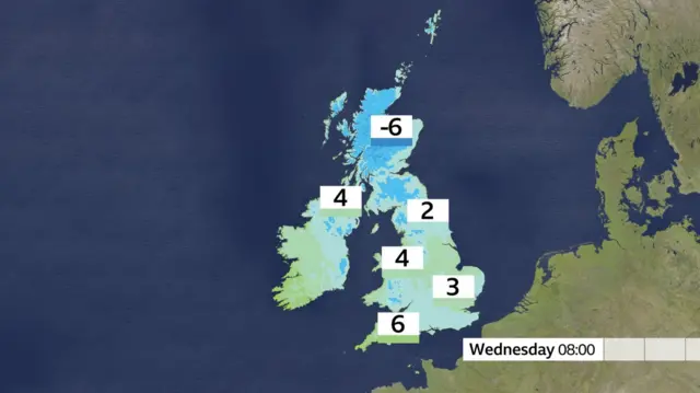
    The coldest place this morning is northern Scotland where the temperature is currently -6C. But elsewhere, it’s actually mostly frost free with temperatures above freezing.

    However, ground temperatures are often a few degrees lower than air temperatures, especially where there is lying snow.

    So there could still be some slippery conditions with ice on untreated roads and pavements.

    Map showing temperatures across the UK. Scotland, at -6 Celsius is the coldest. The southwest of England is the warmest at 6 degrees Celsius.