Summary

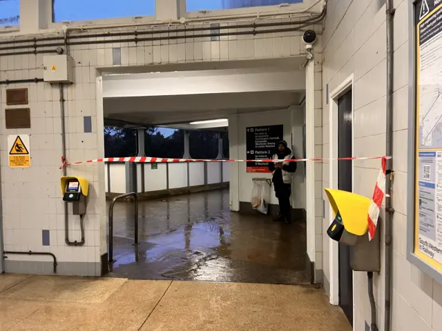
  1. Flooding at Pokesdown Stationpublished at 08:40 GMT 27 January

    Emily Hudson
    South Today reporter

    The train station entrance at Pokesdown in Bournemouth has been blocked by red and white tape.

    Passengers are being immediately turned away as the line is flooded between Bournemouth and Brockenhurst in Hampshire.

    No trains running at all and the staff are saying they have no idea when they will.

    Red and white tape blocking the station entrance at Pokesdown. One worker can be seen behind it. The station floo r is flooded.
  2. Fenny Bridges flooding off A30 in Devonpublished at 08:39 GMT 27 January

    Hattie McCann
    BBC News, South West

    Pictures show flooding of the underpass at the Fenny Bridges turn off from the A30.

    A car driving through floodwater away from the camera. In the foreground is a large amount of water. There are people standing next to the car.
    An underpass in Devon. There is brown floodwater on the ground. The sky is grey and filled with clouds.
    A close up of the side of the road. It is flooded.
  3. 'We need investment in resilience' - council leaderpublished at 08:35 GMT 27 January

    Brazil is wearing a grey jacket over a blue jumper and white shirt and is standing next to a stormy coastline
    Image caption,

    Julian Brazil is calling for increased investment in flood protection

    The leader of Devon County Council is calling for extra investment in infrastructure to protect communities from flooding and storms.

    Councillor Julian Brazil said: "We need to have that kind of resilience, otherwise we feel a bit let down.

    "It's a big thing when these storms suddenly come in and wreck your lives. It's worrying times and we've got to do everything we can to help."

    The Department for Environment, Food and Rural Affairs (Defra) told the BBC it had inherited flood defences in the worst condition on record and had reprioritised more than £100m into urgent maintenance works across the UK.

    A Defra spokesperson said: "We're committed to supporting coastal communities, including in the south west, through our record investment of £10.5bn in protecting against flooding and coastal erosion by 2036, benefitting nearly 900,000 properties."

  4. Railway blocked between Bournemouth and Southamptonpublished at 08:19 GMT 27 January

    Train operator CrossCountry says heavy rain flooding has blocked the line between Bournemouth and Southampton Central.

    "Train services running through these stations will be cancelled, delayed by up to 60 minutes or suspended," it adds.

    Disruption is expected until 10:00 GMT and passengers have been advised they can use their ticket at no extra cost on South Western Railway services between Basingstoke and Bournemouth.

  5. More school closures confirmed in Devonpublished at 08:17 GMT 27 January

    George Thorpe
    BBC News, South West

    The number of schools that are either closed or partially closed in Devon has risen from 25 to 41.

    Devon County Council says closures are now in place at Sandford School, Seaton Primary School and Cheriton Fitzpaine Primary School.

    Partial closures at Barley Lane School in the St Thomas area of Exeter and Woodbury Church of England Primary School have also been confirmed.

    The council is updating its website, external with details of schools which are closed or partially closed.

  6. Disruption to public transport across Devon and Cornwallpublished at 08:17 GMT 27 January

    Great Wester Railway (GWR) said due to flooding several lines have closed and face disruption.

    This includes between Exeter St Davids and Barnstaple, Exeter St Davids and Okehampton, and Exeter St Davids and Taunton.

    There are alterations to train services between Exeter St Davids and Newton Abbot due to a speed restriction.

    In Cornwall, there are cancellations due to flooding between Par and Newquay and between Liskeard and Looe.

    GWR said rail replacement transport was in place.

    Stagecoach SouthWest said due to impassable flooding on the A377, all 5A and 5C services were diverting via the A30 to Whiddon Down to De Bathe Cross, then to Copplestone where they would resume their normal route.

    It added due to impassable flooding at Bickleigh and Stoke Canon, services 55 and 355 were diverting via the M5.

    It added it was the same in opposite direction and apologised for any inconvenience caused.

  7. Number of schools closed in Devonpublished at 07:59 GMT 27 January
    Breaking

    George Thorpe
    BBC News, South West

    Devon County Council says 25 schools are closed or partially closed due to flooding caused by Storm Chandra.

    These include Clyst Vale Community College in Broadclyst, Colyton Grammar School, River Dart Academy in Totnes and Sidmouth College.

    Partial closures have also been put in place at schools including Axe Valley Academy in Axminster, Clyst St Mary Primary School and Yeoford Community Primary School.

    Transport services at some of the schools are also being disrupted, the council says.

    A full list of the school closures and partial closures can be found on the council's website, external.

  8. 'Like driving through a river' in Corfe, Dorsetpublished at 07:55 GMT 27 January

    Michelle Langthorne was on her way to work from Swanage and turned back from Corfe Castle.

    As she drove into Corfe she said the flooding “felt like driving through a river in places”.

    She said the fire service was turning people back “unless an emergency”.

  9. Rainfall totals for past 24 hourspublished at 07:51 GMT 27 January

    Bee Tucker
    BBC South West weather presenter

    Some rainfall totals for the last 24 hours:

    • 100mm (3.9in) White Barrow (South Dartmoor)
    • 75mm (3in) Marden Down (Dartmoor)
    • 73mm (2.8in) Ottery St Mary's
    • 60mm (2.4in) Ashcombe (Teignbridge)
    • 51mm (2in) Wendron (South-west Cornwall)

    The average for south-west England in January is 140mm (5.5in), this has been well exceeded already.

  10. Live updates from BBC Radio Solentpublished at 07:47 GMT 27 January

    On BBC Radio Solent, Steve Harris is on air this morning and keeping you updated with flooding updates and route conditions around Dorset.

    Steve Harris BBC Image
  11. A30 closed near Exeter Airport due to floodingpublished at 07:37 GMT 27 January

    The view from the bridge over the A30 at Exeter Airport

    The A30 is closed between Ottery St Mary and Exeter Airport due to flooding.

    National Highways said officers were on the scene but it was anticipated the road would remain closed for some time.

    “Local diversion routes are in place, however other local roads may also be flooded," a spokesperson said.

    They advised drivers to plan ahead.

  12. Flood warnings across Dorsetpublished at 07:34 GMT 27 January

    At least 64 flood warnings are now in force across the South - 46 of which in Dorset, external:

    • A361 East Lyng to Burrowbridge
    • Upper Frome from Maiden Newton to Dorchester
    • Upper Frome at Maiden Newton
    • Swan Brook at Swanage
    • River Yeo from Sherborne to Yeovil
    • River Wriggle at Chetnole
    • River Winniford at Chideock
    • River Wey from Upwey to Weymouth
    • Rivers Stour and Iwerne at Stourpaine
    • River Piddle from Alton Pancras to Wareham
    • River Parrett (upper) from South Perrott to Thorney
    • River Parrett (upper) at Thorney and Kingsbury Episcopi
    • River Parrett (lower) at Langport Westover Trading Estate
    • River Nadder, Tisbury to West Harnham
    • River Isle from Chard Reservoir to Hambridge not including Ilminster
    • River Isle at Ilminster
    • River Isle at Ashford Mill and Ilford Bridges
    • River Ebble from Ebbesbourne to Nunton
    • River Char at Dolphins River Caravan Park
    • River Cam
    • River Brue and Glastonbury Millstream from Lovington to Highbridge, low lying properties
    • River Brit at Skilling Playing Fields and West Bay Road Nursery
    • River Brit at Riverside and George Street, West Bay
    • River Brit at Newtown, and Southgate Old Mill, Beaminster
    • River Bride from Long Bredy to Burton Bradstock
    • River Bride at Burton Bradstock
    • River Axe (Upper) from Winsham to Axminster, including Chard Junction and Weycroft
    • Middle Stour from Hammoon to Sturminster Marshall
    • Middle Hampshire Avon from Salisbury to Ringwood
    • Lower Stour from Sturminster Marshall to Christchurch
    • Lower Stour at Redhill and Wheatplot Home Sites
    • Lower Frome from East Stoke to Wareham
    • Lower Frome from Dorchester to East Stoke
    • Groundwater flooding in the South Wiltshire Downs - The Dene
    • Groundwater flooding for the Sydling
    • Groundwater flooding for the South Winterbourne Valley
    • Groundwater flooding for the Pimperne Brook
    • Groundwater flooding for the Piddle Valley
    • Groundwater flooding for the North Winterborne, north of the A354
    • Groundwater flooding for the Iwerne
    • Groundwater flooding for the Hooke
    • Groundwater flooding for the Ebble Valley
    • Groundwater flooding for the Devils Brook
    • Curry Moor and Hay Moor
    • Christchurch Harbour Side
    • Brockenhurst and Boldre on the River Lymington

  13. Dorset's Friar Waddon sees 180% of monthly average rainfallpublished at 07:33 GMT 27 January

    Alexis Green
    BBC South Today weather presenter

    Since 06:00 GMT on Monday parts of Devon, Cornwall and Dorset have seen 30-50mm (1.2-2in) of rain.

    This includes the band of rain during the day yesterday, in addition to the overnight rain from Storm Chandra.

    I’ve calculated that Friar Waddon in Dorset - between Dorchester and Weymouth - has already seen 180% of its monthly average rainfall.

    This is from 09:00 GMT on 1 Jan until 09:00 on 26 of Jan.

  14. BBC Radio Cornwall keeping you up to datepublished at 07:19 GMT 27 January

    A head an houlders shot of Neil Caddy, unshaven with short dark hair and glasses, against a pink and purple backdrop of swirls

    On BBC Radio Cornwall Neil Caddy is on air this morning and helping to map the situation as it gets light.

    He'll be checking in with people whose lives have been affected by the massive amount of rain that’s been battering the county while many are still recovering from Storm Goretti.

  15. RNLI 'braced for impact' of Storm Chandrapublished at 07:11 GMT 27 January

    A orange lifeboat and crew crossing fierce wavesImage source, RNLI/Nigel Millard
    Image caption,

    St Ives RNLI in rough seas

    The RNLI in the south west is urging those near the coast or inland waterways to be aware of the dangers stormy weather can bring.

    It says those in exposed locations should be extra vigilant and not take unnecessary risks.

    Joel Ninnes, RNLI water safety manager, says: "Sadly the south west has been hit by a succession of storms already this month, and we are bracing ourselves for the impact of Storm Chandra.

    "With the ground already sodden, cliff edges are unstable and coastal structures already undermined by recent strong winds and rough seas.

    "Our advice is to keep well away from cliff edges and sea fronts."

    Ninnes says all the recent rainfall means rivers are flowing at a much higher rate and river banks are especially slippery and eroded in places.

    "If you do plan to visit the coast or a waterside location, we urge you stay a safe distance from the water as conditions could knock you off your feet or wash you into the sea and keep a safe distance from wet and slippery edges, let someone know where you are going and carry a means of calling for help," he says.

  16. Flood warnings for Cornwallpublished at 07:04 GMT 27 January

    In Cornwall there are flood warnings, external in place at the following locations:

    • River Hayle from Relubbus to St Erth
    • River Cober at Trenear
    • Bolingey Stream from Bolingey to Perranporth
    • River Fowey at Lostwithiel
    • River Fowey from Trekeivesteps to Restormel
    • River Seaton from the A38 to Seaton including Hessenford
    • River Lynher from Berriowbridge to Notter Bridge
    A map with red triangles showing flooding symbols.Image source, Environment Agency
  17. Listen to BBC Radio Devon for the latest updatespublished at 06:58 GMT 27 January

    John Acres
    BBC Radio Devon

    With lots of roads blocked and train services affected, BBC Radio Devon’s John Acres will be keeping you updated as the morning commute gets under way.

    We’ve got reporters heading to some of the worst hit areas, but help us keep Devon safe by calling 0808 100 1034 with your latest updates on how it is where you live.

  18. Flood warnings in place in Devonpublished at 06:48 GMT 27 January

    A severe flood warning has been issued by the Environment Agency for the River Otter (Lower) at Ottery St Mary.

    It said properties and low lying areas would start to flood from about 5:30 GMT on Tuesday and the main areas of concern were Finnimore Industrial Estate, Thorne Farm Way Estate, Luxtons Park, Otter Mill and Tumbling Weir Way.

    It said it was liaising with emergency services and local authorities.

    Flood warnings, external have also been issued for

    • A361 East Lyng to Burrowbridge,
    • Dawlish Water at Dawlish, Monksilver Stream from Combe Sydenham to Williton
    • River Avon at South Brent, Avonwick and Aveton Gifford,
    • River Avon from Didworthy to Aveton Gifford
    • River Axe (Lower) from Axminster to Axmouth
    • River Axe (Mid) at Axminster
    • River Axe (Upper) from Winsham to Axminster, including Chard Junction and Weycroft
    • River Bovey at Bovey Tracey and Heathfield
    • River Clyst at Clyst Honiton
    • River Clyst at Clyst St Mary
    • River Clyst from Broadclyst to Clyst St. Mary
    • River Coly from Colyton to Colyford
    • River Culm (Lower) from Cullompton to Stoke Canon, including Hele
    • River Culm (Upper) at Culmstock and Uffculme
    • River Culm (Upper) from Hemyock to Cullompton
    • River Dart from Buckfastleigh to Totnes, including Staverton
    • River Harbourne at Crowdy Mill, Beenleigh, Bow and Tuckenhay
    • River Isle at Ashford Mill and Ilford Bridges
    • River Otter (Lower) from Salston to Budleigh Salterton
    • River Plym from Shaugh Bridge to Riverside Caravan Park
    • River Seaton from the A38 to Seaton
    • River Otter (Upper) from Upottery to Cadhay Bridge
    • River Sid at Sidbury and Sidford
    • River Teign (Lower) from Chudleigh to Kingsteignton
    • River Yarty from Yarcombe to Axminster
    • River Yeo (Creedy) from Yeoford to Fordton
    • The Gissage Stream at Honiton
    • Umborne Brook from Wilmington to Colyton
    • Washford River, riverside properties from Kingsbridge to Lower Roadwater.

  19. 'Don't take risks', drivers urgedpublished at 06:46 GMT 27 January

    A map showing the weather warnings still in force in the south westImage source, The Met Office
    Image caption,

    A map showing the weather warnings still in force in the south west

    Dan Thomas, Devon County Council cabinet member for highways, urged motorists not to take risks by driving through flooded roads.

    “The roads just can’t cope, we have a situation now where, wherever you live, there will be roads which are flooded.

    "Some of those roads you will see crowning in the middle and you will know it’s safe to drive through but other roads you might not be able to see, and the advice there is not to risk it.”

  20. A351 at Corfe Castle in Dorset closedpublished at 06:36 GMT 27 January

    Dorset & Wiltshire Fire and Rescue Service said the A351 was closed between Norden Park and Ride and C, externalorfe Castle due to flooding.

    It added it would not reopen until water had subsided.